


Les Plans d'Hotonnes par la croix des Terments - les Pelaz

michel.pegaz
User
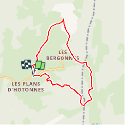

Length
7 km

Max alt
1205 m

Uphill gradient
197 m
Km-Effort
9.6 km

Min alt
1039 m

Downhill gradient
199 m
Boucle
Yes
Creation date :
2019-10-08 19:09:03.289
Updated on :
2019-10-09 14:09:24.5
--
Difficulty : Very easy

FREE GPS app for hiking
 SityTrail
IGN / Geographical institutes
SityTrail Plus
The world is yours!
About
Trail On foot of 7 km to be discovered at Auvergne-Rhône-Alpes, Ain, Haut Valromey. This trail is proposed by michel.pegaz.
Description
Petite Rando aux Plans d'Hotonnes
Positioning
Country:
France
Region :
Auvergne-Rhône-Alpes
Department/Province :
Ain
Municipality :
Haut Valromey
Location:
Hotonnes
Start:(Dec)
Start:(UTM)
709166 ; 5101998 (31T) N.
Comments